


Text | CHAN Tin-kuen
Photo | Hulu Culture, Swire HK Archive Service, GRS
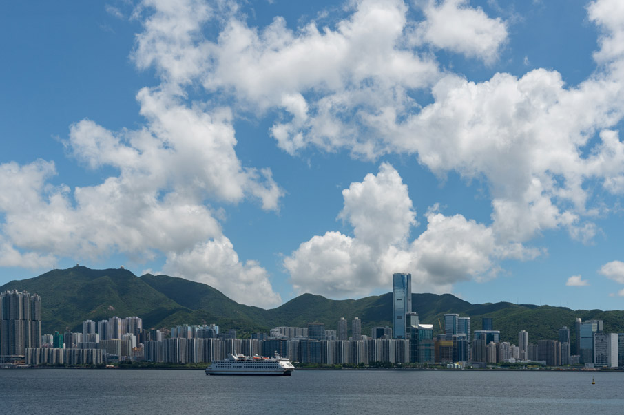
Eastern District: Metamorphosis beyond Industry
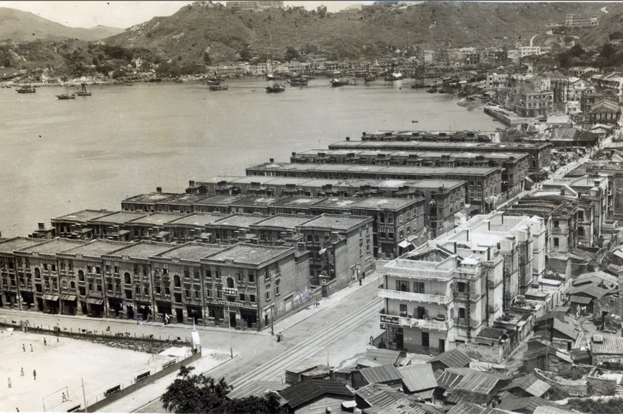
When you walk along Eastern District on Hong Kong Island, it is hard to imagine the sparsely populated cliffs that overlooked this coast a hundred years ago, with no more than a handful of inhabitants in Shau Kei Wan and A Kung Ngam, and the shoreline traced by what are now Electric Road, King’s Road and Shau Kei Wan Road. In 1881, Butterfield & Swire, now Swire Group (aka. Taikoo in Romanised Cantonese), won a seaside lot in Quarry Bay at an auction and constructed a plant for the Taikoo Sugar Refining Company. Later, the Taikoo Dockyard and Engineering Company was built on land purchased east of it. People moved into the area as trams and buses began shuffling along. Today, Eastern District covers Fortress Hill, North Point, Quarry Bay, Shau Kei Wan, Chai Wan and Siu Sai Wan, with 560,000 residents making up 8% of Hong Kong’s population.
Under the development of Swire, Shau Kei Wan and Sai Wan Ho have become company towns.
Islandside Industrial Stronghold
After the refinery and dockyard were completed in 1884 and 1907 respectively, the area became Hong Kong’s largest industrial district, at a time when Island East was just a suburb on the outskirts of the City of Victoria. Swire set up quarters for all levels of staff across the district to attract talents and make their lives easier, with English-style villas built uphill for senior foreign employees, and the Taikoo Sanitarium constructed at Quarry Gap (Tai Fung Au) on Mount Parker. Swire overcame the rough terrain with the city’s first steam-powered Mount Parker Cable Car, which began picking up employees in 1892 but was soon found to be uneconomical. Some of the mountain villas were put on sale in 1931, and the “aerial ropeway” was demolished in the following year.
Sugar production requires a lot of water. Swire built successive reservoirs in the mountains, the largest being Braemar Reservoir (aka. Tsat Tsz Mui, or “Seven Sisters” from Cantonese myth, now Choi Sai Woo). These reservoirs were also piped to Swire workers and local residents as well as other districts in times of drought.
In 1908, Swire built a series of three-storey redbrick quarters for Chinese staff at Sai Wan Ho, a stone’s throw from the Dockyard. There were also shops, canteens, a swimming pool, clubs, bowling greens, cinemas, clinics, schools and other amenities. The self-sufficient community housed over ten thousand people and nurtured a sense of belonging among workers.
The refinery and dockyard moved away in the 1970s and so did the old face of the neighbourhood. Numerous industrial buildings took the place of the refinery and were in turn demolished to make way for Taikoo Place in 1991. The enormous housing estate Taikoo Shing now sits at the dockyard that vanished without a trace apart from a commemorative stone plaque. Swire reservoirs were filled in, and much of Kornhill, the mound across the street from the dock, was levelled to make room for residential towers. Woodside House is the only taipan villa to survive on the foothill of Mount Parker, a relic of the old expat life.
The tip of Eastern District abutting Causeway Bay was another industrial centre at the turn of the century. Many companies built factories on what would become Electric Road and Watson Road and drew new residents in along the way. Royal Dutch Petroleum Co. was the first to arrive with an oil depot in 1897. After the tram opened to traffic in 1904, in came A.S. Watson & Co.’s Aerated Water Factory (1911), the Florida Water bottling plant for Kwong Sang Hong Ltd (1918), the Generating Station of the Hong Kong Electric Co. Ltd (1919), China Sun Film Co. (Minxin) (1923), and several liuli crystal glass factories. The power plant was the biggest of them all and operated until 1978, with City Garden built in its stead.
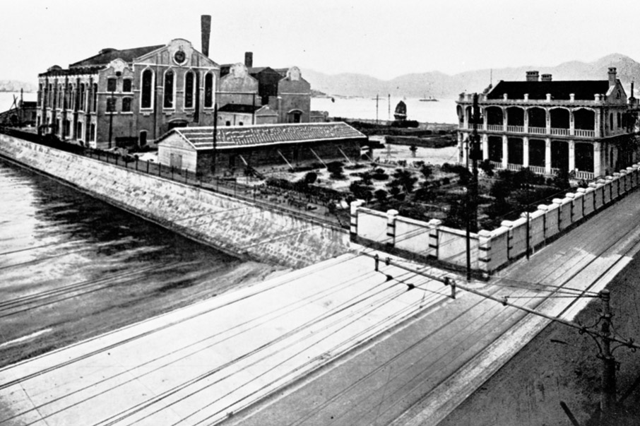
The power plant in North Point in the 1920s.
The former Royal Hong Kong Yacht Club was listed as a Grade II historic building, after revitalisation, it is now an arts centre “Oi!” since 2013.
Entertaining at North Point
Industrial facilities might have covered Eastern in the early days, but there was no lack of leisure venues interspersed within either. In 1908, the Royal Hong Kong Yacht Club built a clubhouse for foreigners on what would become Oil Street. Several sports club then set up swimming sheds for the Chinese on the Tsat Sze Mui seaside (now North Point) to give locals somewhere to exercise. Amusement parks were all the rage, and businessmen built Ming Yuen Garden (“garden of fame”) on the hillsides of Tsat Sze Mui in 1918, attracting many people to drop in by tram for a bit of fun. In 1923, buses shuttled between the Garden and Shek Tong Tsui, but revellers dried up by the end of the 1930s and the attraction closed down.
In 1935, the government cut through the rolling hills to build King's Road and improve transport links, then reclaimed land by Tsat Sze Mui to accommodate newcomers. When the Sino-Japanese War broke out, the richer folk among the Jiangzhe (aka. the Wu) fled Jiangsu, Zhejiang and Shanghai and headed south to take refuge in Hong Kong, often settling in quiet North Point. In 1940, a businessman built Ritz Garden on the beach, along with a dance hall and swimming pools. Hong Kong fell shortly thereafter, and the Japanese occupied Ritz Garden, renaming it Toyokuni Kaisuiyoku-ba.
Ritz Garden reopened after the war, hosted the first Miss Hong Kong pageant, and added the Ritz Ballroom next to it. Other entertainment venues also cropped up in North Point at this point, including Luna Park and Sky Room Night Club (1949), Empire Theatre (1952), and Metropole Theatre and Night Club (1954). Little Shanghai, as the district came to be called, soon earned yet another moniker as Little Fukien (Fujian) when many Fukienese moved in during the 1960s.
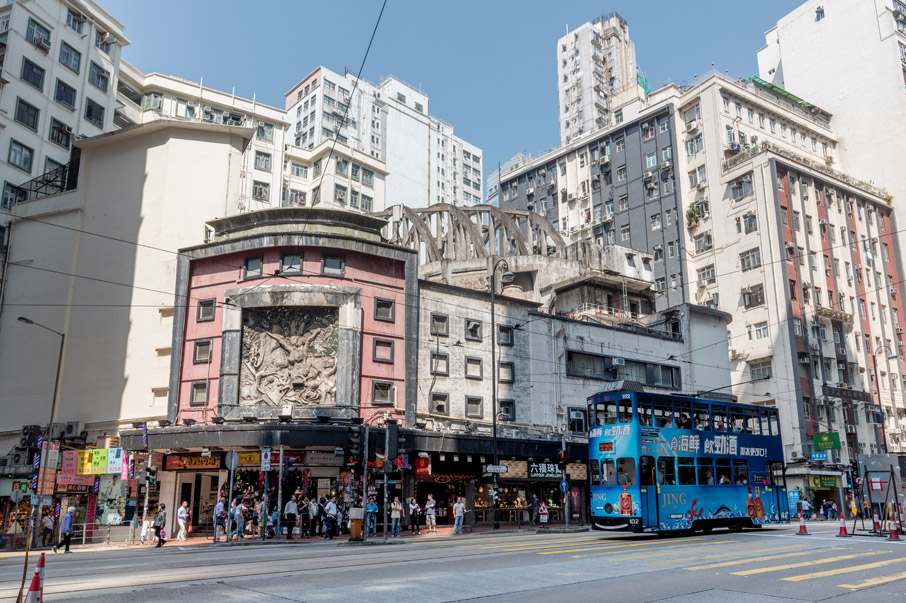
Today, the only North Point landmark that remains from the Little Shanghai era is the former State Theatre, renamed from Empire Theatre. Its facade has a curved-corner frontage, an arch-beam roof structure of parabolic trusses, and underground parking. The main hall had 1,087 seats and mostly screened Western films at first, presumably for a middle- and upper-class audience. The theatre closed in 1997, but the building stands to this day, with the hall leased to a billiard saloon. While not the oldest cinema to survive in Hong Kong, the modernist architecture set the stage for a once-prosperous film industry and breathes the history of the neighbourhood. After campaigns by NGOs, the Antiquities Advisory Board declared it a Grade I Historic Building in 2017.
Many rich Shanhainese lived in North Point after the Second World War, therefore many entertainment venues were built, such as cinemas and night clubs.
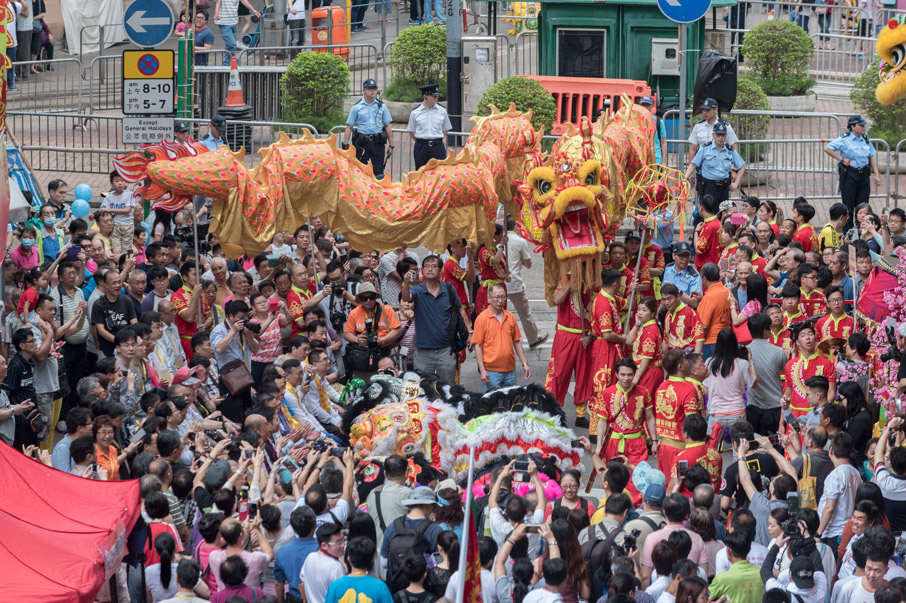
The largest festival in Eastern district is definitely the Birthday of Tam Kung, many people join the parade.
Winnower Gods
Facing Lei Yuen Mun, Shau Kei Wan is a bay named after the flat winnowing wicker basket it once resembled. Barricaded by mountain chain, the spot has sheltered fishing boats from the elements since time immemorial. The rocky shore also attracted the Hakka, known for their quarrying skills, who became the first landside inhabitants of Shau Kei Wan. A British survey in 1841 counted 1,200 residents (excluding fishers), with another 200 living in nearby A Kung Ngam.
Quarriers and fishers often travelled by water and asked sea deities for blessings. In 1845, the residents raised funds to build a Tin Hau Temple on a nearshore rocks (hence aka. Hoi Shum Temple, “heart of the sea”) to worship the goddess of heaven known as Mazu elsewhere. Another one was built for her on Shau Kei Wan Main Street East in the 1870s, along with a Fuk Tak Tsz for the Earth God. The quarry grew more prosperous still, so the stonecutters built a Tam Kung Temple on the shores of A Kung Ngam in 1905. Tam Kung is worshipped by the Huizhou Hakka, having allegedly commanded the winds to the amazement of fishers.
Hoping to convert the Hakka, the Basel Mission also came to Shau Kei Wan early on and built a Christian church on the knoll by Main Street East in 1862. The Mission was renamed Tsung Tsin Mission of Hong Kong in 1924, and the church became its Shaukiwan Church, twice rebuilt since and featuring a new look despite sitting on the same Basel Road.
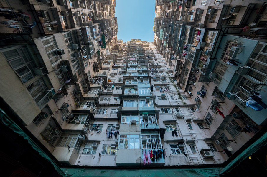
Montane Mansion in Quarry Bay has become the hotspot among the citizens, unfortunately, it has also brought nuisances to the residents living there.
In the early days, British army has already set up forts in Lei Yue Mun, pro-viding defence for the East part of the Victoria Harbour.
Guarding Carp Pass
The eastern entrance to Victoria Harbour known as Lei Yue Mun (also spelt Lyemun, “carp pass”) is an important naval choke point. The British army wasted no time in setting up Saiwan Barracks in 1844, only to abandon it to the plague soon after. In 1878, the United Kingdom proposed military installations in Hong Kong and Kowloon to strengthen the city’s defence. Over time, Eastern District hosted North Point Battery (1880), Lyemun Barracks (1884), Lye Mun Re-doubt and Battery (1887), and Saiwan Hill Redoubt (1895) and Battery (1898).
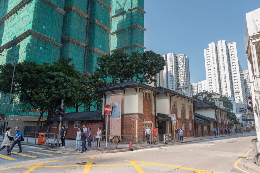
By the early 1940s, these military faci-lities had become obsolete and the succumbed to the Japanese in no time. After the war, they were used as a training base for the British military and were returned to Hong Kong government in 1987. Lyemun Barracks was converted into Lei Yue Mun Park and Holiday Village in the following year, with its 14 buildings assessed and three of them declared monuments in 2016. Conversion work at Lye Mun Redoubt and Battery began in 1993, and the Hong Kong Museum of Coastal Defence opened in 2000 to illustrate the history of Hong Kong's defence over more than six centuries.
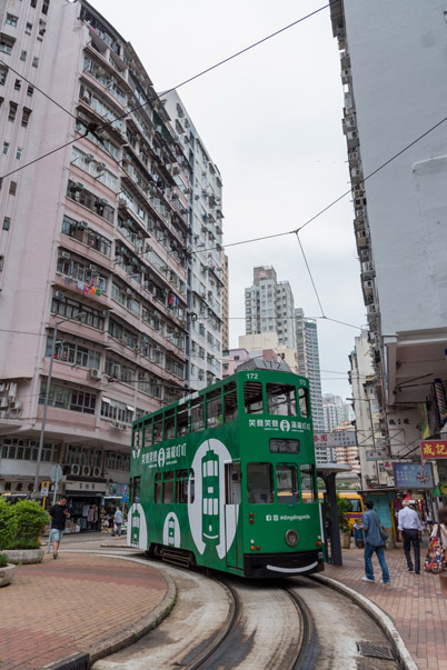
The roundabout at the main tram station in Shau Kei Wan Main Street East.
After more than a hundred years of development, Island East is now diversified community with both commercial and residential activities.
Bay without Winnowers
The population of Hong Kong rose sharply after 1949. The foothills of Shau Kei Wan and Sai Wan Ho were covered in “squatter settlements”, with 13 villages and tens of thousands of people living in these slums at their peak. Churches, the government and other organisations provided community services and built schools. In the 1960s, the Hong Kong Housing Society built Shau Kei Wan’s first public housing estate by the slopes on Main Street East. Ming Wah Dai Ha was named after Bishop Ronald Owen Hall, a founding member of the Housing Society, and had 13 blocks built in three phases. Fishers who moved ashore and slum dwellers soon relocated to the estates. By the 1980s, the government started to raze the foothill slums to build numerous public rental estates and Home Ownership Scheme (HOS) flats, and the view changed anew.
As the fishing industry declined in the 1970s, the fishing-port ambience faded away from the typhoon shelter. Shau Kei Wan boomed after the Island Eastern Corridor and the MTR Island Line opened, and the government filled out the typhoon shelter for building public housing, HOS estates and private residential towers for more than 30,000 people. Shorn of it winnower, Shau Kei Wan now boasts a new typhoon shelter further out into the sea.
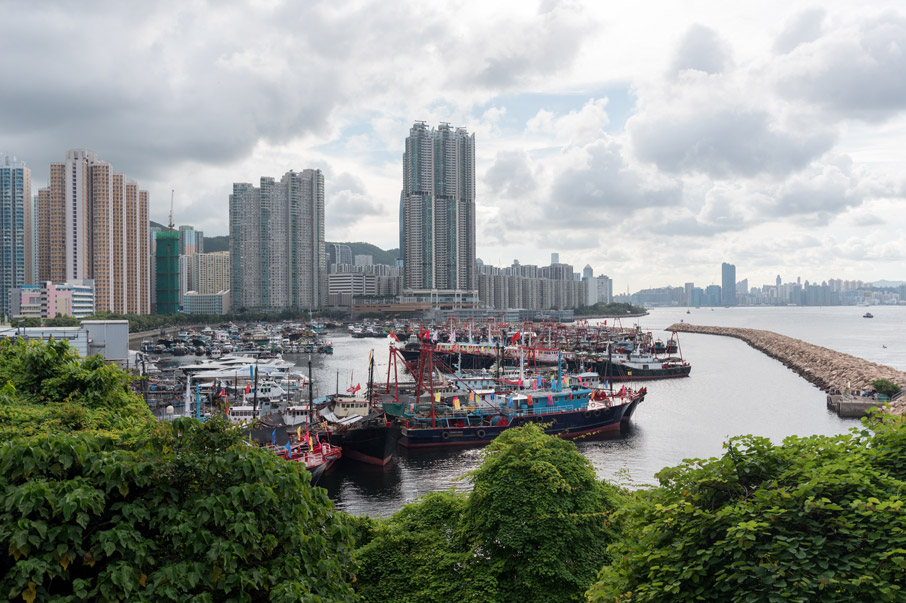
After the 1970s, the fishing industry became less significant, with the urban development, the crowded Shau Kei Wan Typhoon Shelter will not be seen anymore.


