


Text / Dr. Leung Ping Wah
Photo / Hulu Culture
Shatin is located north of Kowloon and south of Tai Po, the district includes Tai Wai, Shatin, Fo Tan, Ma Liu Shui, Shing Mun East and Ma On Shan. In the early days, Shatin was a barren field covered with thorny bushes and brambles, it was known as the “Thorns Garden.” Back then, the main village area was built on the opposite banks of Shatin Hoi (now Shing Mun River); upstream of the river was very clean and clear in those days, hence it was referred to as “Lek Yuen” – meaning the source of clear water. It was also called “Lek Yuen Fort” or “Lek Yuen Cave”.
Name Origin
“Lek Yuen” is located at the waterfront, and a large patch of sandy beach was always exposed at low tide; gradually it had attracted people to do farming there, and turned it into a field for agriculture (in the beginning it should have been a salt water field, the name Shatin literally translates to Sand Field, hence we have the origin of the name Shatin). Geographically this area is protected by mountains on three sides, so people also called it the “Shatin Valley”. Some neighbouring villages then also started to name themselves after Shatin, “Sha Tin Wai” and “Sha Tin Tau” being prime examples.
In 1898, the British had forced China to sign the “Convention for the Extension of Hong Kong Territory”, in which, China had to let out all the land from the North of Boundary Street to the south of the Shenzhen River plus all the two hundred something islands in the vicinity on a land lease to the British for 99 years. Britain then began reconnaissance and received the New Territories. When the officer questioned the villagers in Sha Tin Wai about the name of their village, they answered “Shatin”, so the British used the name “Shatin” to replace “Lek Yuen “.
Historical Overview
Shatin has been inhabited since the Ming Dynasty (1368-1644). Those people who came from the mainland during the Ming Dynasty are now referred to as natives. Villages were built on the fertile land with abundant water supply; such as Chik Chuen Wai (Tai Wai), Siu Lek Yuen, Tin Sum Wai, etc. Those who came later during the Qing Dynasty called themselves Hakka people; they could only build their villages higher up on the hillsides, sometimes even on hilltops.
There is something known as the Nine Alliance in Shatin. There were close to fifty villages in Shatin, from time to time the villages had conflicts over land and water rights, disputes and even fights often occurred. Therefore, small groups of neighbouring villages formed alliances to build up sufficient strength to bargain or fight against one another (such as Fo Tan Yeuk, Tin Sum Yeuk, Tai Wai Yeuk, etc.). Within each alliance, joint defense for their own township was organized; they also encouraged marriage among the villages within the same alliance. Each alliance has its own patron saint and ritual activities. Once every ten years, each township would hold a festival (Da Jiu) for their worship rituals to pray for peace and to promote solidarity and cooperation.
Livelihood
Farming was their livelihood, mainly growing rice and vegetables etc., mostly for personal use, only a small surplus would be available for sale. They also kept a few livestock and went up to the hills chopping up firewood for extra income. Since Shatin is located at the seaside, many villagers also went fishing in the sea for fishes, shrimps, clams, oysters and scallops.
Some villagers also engaged in the production and the trading of spices. During Ming and Qing Dynasties, fragrant wood was planted all over Dongguan area; juice extracted from the roots of these trees can be used to make perfume and was known as the famous “Guan Spice”. The “Lek Yuen” area was also rich in fragrant wood. Since waterway transportation in Hong Kong was easy, fragrant wood was first transported to Tsim Sha Tsui (or known as Heung Po Tau, i.e. the pier for the shipping of fragrant spices), and then shipped to Shek Pai Wan in Wong Chuk Hang on the Hong Kong Island, then shipped onwards to the mainland.
Shatin has always been a major transportation channel leading to the mainland from Hong Kong. During the Boundary Move in the seventeenth century, the Seamen’s Strike in the early twentieth century, the General Canton-Hong Kong Strike and Boycott, the Repatriation Policy during Japanese occupation, Shatin was where everyone in Hong Kong must pass through when they travelled to or from the mainland by land. Besides, in the old days, salt production in Kowloon also had to be transported via the Shatin Pass Road old trail to be sold in the mainland. And, for sea transport, Yuen Chow Kok was originally where all the mainland vessels must anchor and berth upon arriving Kowloon.
Vicissitudes of Life
In the first year of Emperor Kangxi’s reign in the Qing Dynasty (1662), in order to prevent coastal residents offering any aid to the military leader Cheng Cheng-kung in Taiwan, the Qing court implemented a boundary move, whereby all coastal residents in five provinces must move inland fifty miles and stayed clear of the coastline. All of a sudden, “Lek Yuen” became a barren field and turned into an ideal hideout for bandits. On the eighth year of Kangxi (1669), the Qing court let the coastal residents return to their home, but “Lek Yuen” had to wait until the twenty-third year of Kangxi (1684) before the original residents were allowed to return home, much later than the other regions. At that time many villagers had already settled elsewhere permanently and did not return. To help restore the economy, the Qing court therefore actively encouraged other people to move in, they were mostly Hakka people from Jiangxi, Fujian, Huizhou, Chaozhou, Jiaying, and other places.
When the Japanese started to invade Hong Kong, many residents fled, some villagers stayed behind and fought with the Japanese, while others took shelter in a Christian Centre on the nearby hill Tao Fong Shan. The Tao Fong Shan Christian Centre was founded by Norwegian Missionary, since the Japanese had not wage war on Norway, so they had caused no nuisance there. However, the Japanese suspected that the Shatin villagers were harbouring guerrillas, so they adopted the “Three Alls Policy”; which meant “Kill All”, “Burn All”, and “Rob All”. As a result, residents in Shatin had to lead a vagrant life during Japanese occupation.
In 1956, an Australian overseas Chinese by the name Lau Shui first built a “Shatin New Market” on a piece of saltwater field (150,000 sq.ft.) next to the train station, and set up 125 temporary sheds there. All kinds of shop had appeared and business in the new market was good. Unfortunately, in 1962, Hong Kong was hit by one of the most destructive typhoon in the history of Hong Kong, typhoon Wanda, the entire Shatin Market was in ruins, many fishing boats sank and over one hundred people were killed. Although the Shatin New Market was rebuilt afterwards, in view of the need to increase the development efforts in Shatin, the Government granted Sun Hung Kai Properties Limited the right to demolish the market in 1979 and turned it into a large-scale shopping mall called “New Town Plaza”, thus enabling the rapid development in Shatin.
Ma On Shan is located in the northeast of Shatin; the arc-shaped top of the hill looks like a saddle on horseback, hence the name. There is an old village on the hill called Ma On Shan Village; it has more than two hundred years of history. After the war, the village became deserted due to the lack of transportation. Nonetheless, Ma On Shan was famous for its rich iron ore reserves. Large scale iron mining was carried out by The Mutual Mining and Trade Company owned by Taishan people, using the technology of Japan. During the postwar heyday they employed as many as five thousand miners. In the early 1950s, many people in Hong Kong could not get a job and economy was in a slump, many Kuomintang soldiers fleeing from the mainland and other refugees became miners in Ma On Shan to earn a living. At that time, both the The Evangelical Lutheran Church of Hong Kong and St. Joseph’s Church spread the gospel to the miners and provided welfare to them as well. Until 1976, the mining operation came to a close. From 1979 onwards, the Government started to develop Ma On Shan into another new town, rail connection has also been added in recent years.
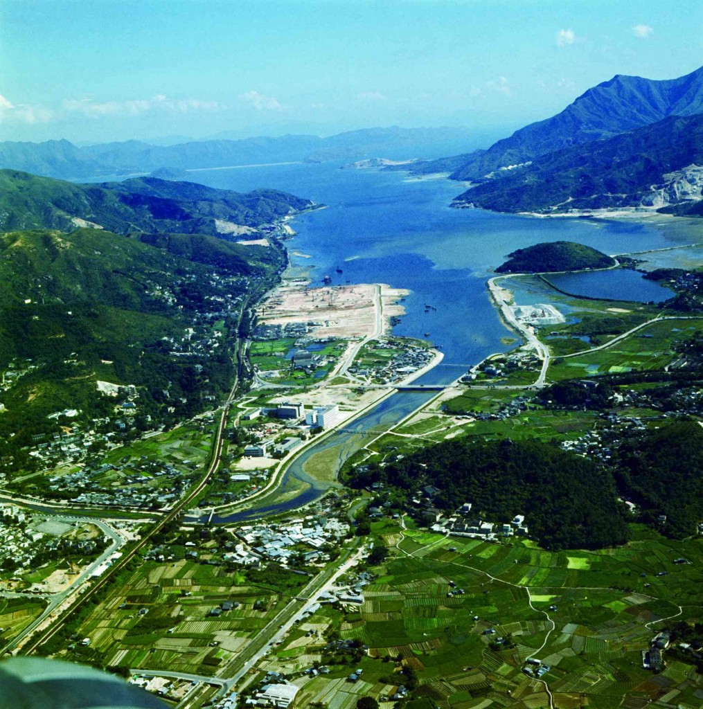
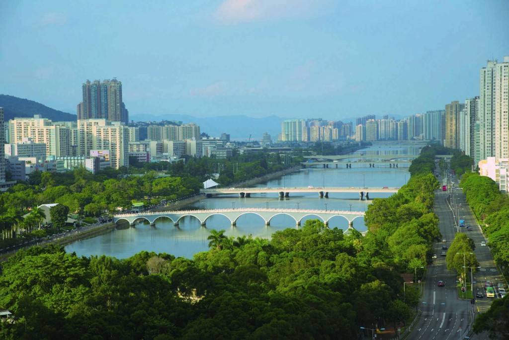
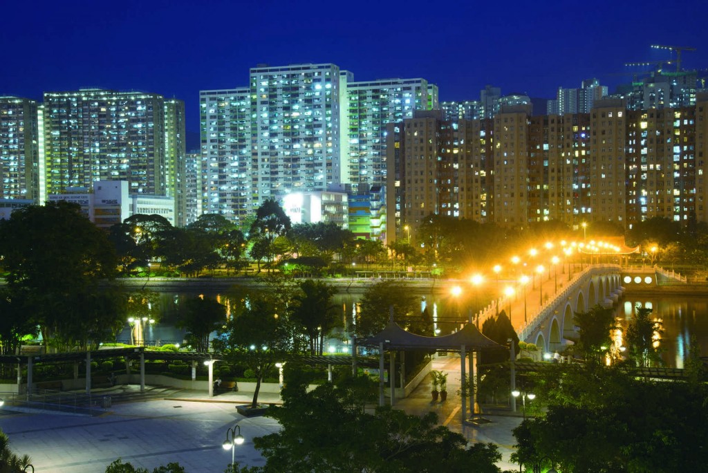
Starting from 1970s, a large-scale reclamation project was launched at the coast of Shatin city centre with a 7 km long, 200 m wide artificial channel, Shing Mun River, in the middle. Today, both sides of the river are residential and recreational hub for the general public while the farmlands have eventually disappeared. (Photo / Information Services Department)
Face-lift
Two or three decades after World War II, Shatin was still a rustic village, it was also a favourite spot for school trips and outings. In 1963, the Chinese University of Hong Kong campus in Ma Liu Shui was completed. In the mid-1970s, Shatin had gradually developed into a new satellite town. Many large-scale public housing estates were built, such as Lek Yuen Estate, Wo Che Estate, Sha Kok Estate, Yuet Ming Estate, etc. On the other hand, a number of large-scale private estates were also developed and ready for occupation, such as Shatin City One, Belair Gardens, Jubilee Garden and the Royal Ascot. Besides the new Shatin Racecourse, other facilities for a modern city were also added, including a City Hall, libraries, museums, hotels, etc. A rustic village has transformed into the Shatin New Town in four decades. (Note: In recent years, I have written a set of “Shing Mun River Capriccio” to describe the past and present changes in Shatin; the lyrics of a rap and three other songs named “Shing” (City), “Mun” (Gate), “Ho” (River), fully reflects the vicissitudes of Shatin.)
Today, the population of Shatin remains the highest among the eighteen districts in Hong Kong. The well-equipped facilities and infrastructures set a good example for other new town development projects.
With China’s opening up reforms and the return of Hong Kong, Shatin becomes more and more important. Transportation has developed by leaps and bounds. In addition to the Tai Po Road and Kowloon-Canton Railway which were built in the early 1910s, now there is Tolo Highway linking to the city, the Lion Rock Tunnel, Tate’s Cairn Tunnel, Shatin Heights Tunnel, and the Shatin to Central Link (SCL) – a new railway line which will be open to traffic after a few years. Shatin has now developed into an important transportation hub linking up Hong Kong Island, Kowloon, New Territories and China. Shatin will become more and more important in the future.
Shatin with a myriad of people and households gives us an important insight of people-oriented perspective during the process of city planning.


